
| Archive | www.flasla.org |
Smokey Hollow Historic American Landscapes Survey
![]() Print this Article | Send to Colleague
Print this Article | Send to Colleague
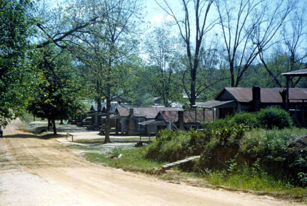
The Florida Chapter ASLA launched the Historic American Landscape Survey six years ago and has produced documentation for a few small sites. Now underway, the Smokey Hollow HALS is the first extensive project in Florida.
Computer drawn maps, large format photography and a book-size, written historical narrative about Smokey Hollow are heading to the Library of Congress. Blueprint 2000, the Tallahassee-Leon County agency building the thirty million dollar Cascades Park, commissioned this Historic American Landscapes Survey of Smokey Hollow.
The U.S. Congress created the Historic American Landscapes Survey (HALS) in 2000 and established it in the National Park Service Heritage Documentation Programs along with the Historic American Building Survey (HABS, established in 1936) and the Historic American Engineering Record (HAER, established in 1969).
HALS documents significant historic landscapes of the United States and its Territories, which can range from gardens to cemeteries to parks to neighborhoods. Using historic ground and aerial photos, land surveys, plats, property records and oral histories, HALS documents the cultural history of a place, the story of people who occupied the landscape, their customs, their landmarks, social traditions, and how the landscape evolved over time. The National Park Service submits completed HALS projects to the Library of Congress where they become a permanent record of our nation and are accessible to the public.
The American Society of Landscape Architects, the National Park Service, and the Library of Congress entered into a Memorandum of Understanding in 2001 that established the Historic American Landscapes Survey to document historic landscapes in the United States and its territories to serve as tangible evidence of our nation’s heritage and development. In 2010, the three organizations signed a new Tripartite Agreement that made HALS a permanent federal program.
The National Park Service administers the planning and operation of HALS which includes: selecting and approving landscapes for documentation, standardizing formats and developing guidelines for recording landscapes, catalogs and/or publishing the information when appropriate.
The Library of Congress accepts and preserves HALS documents, furnishes reproductions of material, and makes records available to NPS.
The ASLA Professional Practice department works with ASLA’s Historic Preservation Professional Practice Network (PP-PPN) to provide advice on identifying, selecting, and documenting historical landscapes. The ASLA HP PPN, through its HALS subcommittee, oversees the nationwide identification of historic landscapes that merit HALS documentation. Beginning in 2014, ASLA now requires each chapter to include HALS in its executive committee. The Florida Chapter established a HALS program in 2007.
HALS has entered eight Florida sites into the Library of Congress. Measured and interpretative drawings, photographs, and written histories may be viewed on the Library of Congress website.
HALS FL-01 is Barrancas National Cemetery at the U.S. Naval Air Station, 80 Hovey Road, Pensacola in Escambia County. Many Union and Confederate dead are interred. HALS large format photographs were produced by the National Park Service. Some of these photos are stunningly beautiful.
David Driapsa, ASLA