Alberta Data Partnerships – The Alberta Advantage
Print this Article | Send to Colleague
Sher Kirk, Operations Director, Utility Safety Partners
Geospatial data is critical to the operation of Utility Safety Partners and its stakeholders. Current and accurate mapping datasets are required by planners, builders, excavators, locators, municipalities, oil and gas industries and utilities. Access to quality basemaps will allow industry to take advantage of emerging technologies, AI, and data mirroring to develop new ways of delivering accurate map data to the field.
In most provinces and states, digital map bases are stitched together from available pieces of information – which are extremely expensive to purchase and maintain over time. In Alberta, complete spatial data layers are available to industry and the public through a visionary and unique partnership started in 1997. Alberta One-Call was at the table when Alberta Data Partnerships (originally Spatial Data Warehouse) was formed, recognizing the importance of quality mapping even then. USP still sits on the Board of Directors today.
Alberta Data Partnerships (ADP) is a non-profit, public-private partnership created to manage and distribute comprehensive digital datasets for the province. It works to ensure that spatial data is accessible, accurate, and affordable for Albertans.
Structure and governance
- Public-private model: ADP took over the management of Alberta's digital mapping datasets from the provincial government. It is governed by a board of directors that represents a variety of stakeholders, including the Government of Alberta, municipalities, utility companies, forestry, and the oil and gas industry.
- Operating partner: ADP's day-to-day management and data distribution is handled by Altalis Ltd., a private company with which it has a joint venture agreement to fund the activities of ADP.
Datasets
- Data access platform: Through its website, Altalis.com, users can explore, view, and acquire both free open data and commercial data products.
- Available datasets: The datasets managed by ADP include:
- Property data: Cadastral, Title, and Dispositions mapping.
- Base map data: GIS/CAD base maps and Alberta boundary data.
- Terrain data: Digital elevation models (DEM), LiDAR, and hillshades.
- Imagery: Ortho imagery and satellite imagery.
- Utility data: Facility data, such as poles and conductors.
Benefits of the public-private partnership
- Cost savings: Since its creation, the model has resulted in large cost savings while improving data and delivery systems. Estimated savings to Alberta taxpayers are between $60 and $115 million.
- Improved data: Stakeholder input is incorporated into the continuous improvement of datasets.
- Improved access: The partnership makes provincial mapping products immediately accessible to all sectors of industry, government, and the public.
- Neutral third party: ADP provides a secure and professional environment for data sourcing, delivery, and sharing.
Other initiatives
- Open Data Areas Alberta (ODAA): ADP collaborated with the Government of Alberta to make extensive, high-quality data available to the public for free under the Open Government Licence.
- Municipal partnerships: Through agreements with ADP, municipalities like Edmonton and Calgary have streamlined access to provincial cadastral and titles mapping information.
- Artificial Intelligence (AI): The Alberta government has an AI data centre strategy that includes partnerships with industries to attract investment and modernize digital infrastructure.
- Registered Interests On Titled Land (RITL): ADP is currently seeking funding to create a data set that would include all registered assets on a title. This will allow planners to look in one place to determine land use, ROWs and ownership.
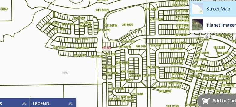
This unique partnership gives Alberta industry a distinct advantage, both in availability of geospatial data and cost-savings in obtaining datasets required for understanding land use and ground disturbance. USP continues to work with AltaLis to access cadastral data through Web Feature Service to display more accurate information in our ticket creation software. More accurate maps lead to more accurate dig site mapping and improved safety outcomes. (see comparison images below)
Current Google Map display of area with recent municipal development. No roads or lots are visible.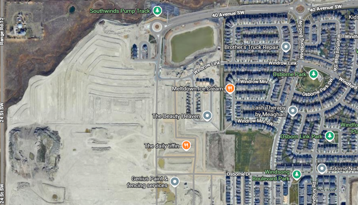
AltaLis’s Cadastral map layer of same area, showing lots.