The Map Is All
Print this Article | Send to Colleague
The Map is All
The importance of mapping an accurate dig site when you place a locate request cannot be overstated. It is the most important piece of information on your ticket, so when you receive the email copy of your ticket back, it is critical that you take the time to review that map. Does it cover your entire dig area? Is it in the correct geographic location?
The dig site polygon determines which asset owners are notified that you require locates or a clearance to complete your work safely. It is the ONLY piece of information on your ticket that makes that determination. Getting it wrong can result in delays, ticket corrections or cancels, and worse, it can result in an asset owner not being identified and notified – leaving you exposed to the risk of a line contact when you dig.
The mapping system in the Before You Dig Partners software (OneCallAccess, developed and provided to us by Pelican Corporation) has two components:
- The Base Map
This is the information that is gathered and displayed to users to assist them in identifying the location of their dig site. There are different layers available to search by and to display for clarity. For example, you might see Google Maps displayed, with a Street Line overlay, or, in rural areas, you may turn on the ‘Grid Layer’, which displays the grids for Township, Range, Section, and Quarter Section.
The base map is complicated to obtain, expensive to license and modify to display properly and almost never keeps up with development of new areas and streets. While we might not have a perfect base map, we are constantly trying to improve it and to identify and source affordable and accessible map layers that we can add to make it easier to find every dig area. - The Member Registration Layer
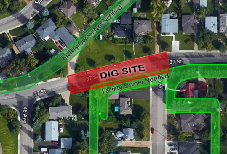
On this ‘second’ layer of the map, we incorporate thousands of polygons that identify the geographic locations where our registered asset owners have indicated they need to be notified. Members who have high confidence in the accuracy of their data may have registered polygons with very small buffers. Members who have less confidence, may choose to register entire quarter sections or towns where they want to be notified. This layer is not displayed to the user, making it especially important that you map accurately, as a member’s polygon may be just outside the boundary of what you draw.
When you draw a dig site polygon, the red area that you indicate as your dig area is compared to the Member Registration layer, and if it intersects or touches a member polygon, that member is notified on your ticket and has to respond with a clearance or locates. If you work outside of the dig area you provided, you may contact a line that was not identified, putting you at risk of injury.
 |
Take the time to ensure you map correctly, every time. If you are unsure of your map, please use our live CHAT button and an agent can help you complete a safe and accurate map. If you call in your locates, our agent will do their best to map accurately based on your description, but it is up to you to look closely at the ticket when you get it and contact us immediately if the dig area is not completely covered correctly. Your life may depend on it.
Sher Kirk - Operations Director - Utility Safety Partners
