
Let’s talk Mapping – We’ve come a Long Way!
Print this Article | Send to Colleague
A utility notification service relies on GIS technology. When a proposed dig site is drawn on a base map, the polygon of the dig area is checked against layers of data containing the shape files and location information of potentially thousands of registered facilities. The system determines which utility owners need to be notified of the excavation based on the proximity to their assets to that dig site polygon.
The spatial data industry has made huge advances in the last few years and continues to change and improve at lightning speed. In a world where you can see a street view of your childhood home or go to a city’s online map and see lot numbers and addresses of the newest areas, it can be difficult for users of Click Before You Dig services to understand why it isn’t just that easy on our system, too.
The simple answer is: we are on a timeline that requires software-specific development and a lot of money to reach each target along the way. I recognize the shortcomings of the current Google map solution, but I also see clearly how far we have come and how close we are to where we want to be.
A demonstration: How a locate request for 1349 Rocky Point Drive in Sometown, Alta. would be mapped at various points in time.
2003: 1349 Rocky Point Drive is entered in the address field of the ticket. We did not have map data for Sometown, so we notify every registered utility who lists Sometown in their “notify” listing.
2008: The map base now recognizes Sometown and its main streets, but not Rocky Point. We notify any member whose database touches any of the eight closest street segments around the nearest intersection we have data for.
2013: The map base now includes streets, lots and addressed parcel data. The agent can find the lot and map the front of the street – if the address was added to the database more than two years ago, because that is how long it takes to modify all the data layers from multiple sources and upload them into our mapping software. In newer areas like Rocky Point, we guess by taking instruction from the excavator on the phone and mapping a large enough area to ensure the right utility owners get notified.
On the agent side, the map for this address looks like this:
 |
The hatched area outlined in red is the drawn polygon. The black polygons represent a utility’s notification area being contacted by the dig area. The notified utility owners do not receive a map – only the ticket information and two GPS coordinates that give the mapped location’s boundary.
2018: The map layers we have built over time are too large to display on a cloud-based system, for online users and are abandoned (for now).
The online user searches the Rocky Point area and maps the approximate location, based on the information and site plans he has access to. The contractor can better draw the area even though the new development is not shown in Google Maps, and only members with assets inside the red box are notified
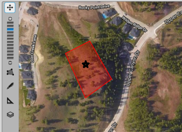 |
In the next three to five years, we will have accurate up-to-date map sources to create a web-ready map layers which we host on a server. The software will interact with our WFS server to pull the map data onto the screen for the user to draw on. Utility owners will receive the actual geometry of the drawn object to place on their internal maps (which is the case now, but not all utility owners have developed their internal systems to use the data). When screening or replying to the excavator, utility owners can show their assets in relation to the drawn dig site. The excavator could potentially receive responses much faster, and fewer and more accurate notifications to utility owners will help the damage prevention process keep up with ever-increasing volumes.
Continuous improvement and enhancement may eventually get us to the point where utility owners will send GPS location data of their assets directly to your phone. We aren’t there yet, but when I look back at how fast we are moving forward, it won’t be long.
-Sher Kirk
