
| July 29, 2014 | |
Infrastructure: Freeport, Houston Jacksonville
![]() Print this Article | Send to Colleague
Print this Article | Send to Colleague
Two new gantry cranes arrived fully erect and ready for installation at Port Freeport on July 19, completing a voyage that began in Shanghai, China, on May 7. Dredging has started on the first of two improvement projects to deepen the Port of Houston Authority's container terminal channels from 40 feet to 45 feet, matching the depth of the Houston Ship Channel. Top officials from the National Oceanic and Atmospheric Administration (NOAA) joined local maritime leaders last week in Jacksonville for a ceremony dedicating a Physical Oceanographic Real-Time System designed to save money, improve safety and enhance research regarding conditions in the St. Johns River.
Port Freeport Takes Delivery of New Gantry Cranes
Two new gantry cranes arrived fully erect and ready for installation at Port Freeport on July 19, completing a voyage that began in Shanghai, China, on May 7.
Each crane stands approximately 300 feet high, measures 80 feet wide, has lifting capacity of 75 tons, and can span 18 rows of containers. They will occupy a portion of Berth 7 at the port’s new Velasco Terminal.
Following landing, the cranes will be taken through a detailed commissioning process lasting four to six weeks before a formal hand-over.
"This commitment from the commissioners demonstrates that Port Freeport will make the financial investments to support the petrochemical industry in our region," said Port Director Glenn Carlson. "The cranes will allow us to attract new services and business to Port Freeport, which will lead us in a new strategic direction that we are very excited about."
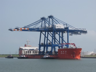
New cranes arriving in Port Freeport aboard the Zhen Hua 28.
Photo/Port Freeport
Houston: Dredging on Barbours Cut Channel Project Under Way
Dredging has started on the first of two improvement projects to deepen the Port of Houston Authority's container terminal channels from 40 feet to 45 feet, matching the depth of the Houston Ship Channel. The contractor has been onsite sincere May preparing the dredge material placement areas to receive material. The Barbours Cut Channel is being dredged first to ready it for the arrival of new container cranes. Dredging will begin on the Bayport Channel this fall.
"It was a great team effort between the U.S. Army Corps of Engineers and the Port Authority to get these projects under way," said Port Commission Chairman Janiece Longoria. "The Corps produced an economic analysis report, which found that the minimum net benefits of the improved Bayport and Barbours Cut channels to the U.S. economy will be $2.9 million per month or about $35 million a year. The commencement of this project confirms that the Port of Authority is committed and ready to handle larger container ships in Houston."
The projects will be completed using a combination of electric- and diesel-powered dredges, working around the clock and weather permitting. The channels will also be widened or realigned by up to 100 feet to better accommodate post-Panamax ships.
About half of the expected 6 million yards of total material collected from the two channels will be for beneficial use to raise levees.
The port authority is funding the projects at its sole cost to ensure the channels are ready in advance of the opening of an expanded Panama Canal in 2016. The work is expected to be completed in the third quarter of next year.
$2.8 Million Physical Oceanographic Real-Time System (PORTS®) Launches in Jacksonville
Top officials from the National Oceanic and Atmospheric Administration (NOAA) joined local maritime leaders last week in Jacksonville for a ceremony dedicating a new sensor system designed to save money, improve safety and enhance research regarding conditions in the St. Johns River.
The $2.8 million Physical Oceanographic Real-Time System (PORTS®) offers data from 18 stations comprised of 46 sensors located along 67 miles of the St. Johns River in Northeast Florida.
The system provides instant tidal and weather information to commercial, military and recreational users, and compiles research data for use by academic institutions, environmental scientists and agencies such as the National Weather Service.
"Our nation's ports are critical cogs in our country's economic engine," said NOAA Administrator Kathryn D. Sullivan. "NOAA's PORTS system gives shipping companies, captains, fishermen and others vital environmental intelligence that helps them navigate these waters more safely and efficiently. This is a win-win for the port, our partners, the surrounding communities and every business and industry that depends upon this flow of goods."
Knowledge of the currents, water levels, winds and density of the water enable shippers to optimize cargo loads, knowing that vessel captains and pilots are using every inch of available channel depth safely, maximizing profits and efficiency.
"The real-time information provided by PORTS is invaluable to balancing JAXPORT's dual priorities of enabling safe and efficient commerce while protecting the natural resources so critical to our quality of life in Northeast Florida," said Brian Taylor, CEO of the Jacksonville Port Authority. "We know this system makes us a more competitive port and will help us fulfill our mission of contributing to the region's overall vibrancy."
NOAA developed the system. NOAA also collects, quality controls and disseminates the data, which are updated every six minutes. The Jacksonville Marine Transportation Exchange purchased and installed the system financed by a Federal Emergency Management Agency grant.
![]()
![]()
![]()
![]()

|
Asociación Americana de Autoridades Portuarias
1201 Maryland Ave SW, Suite 860, Washington, D.C. 20024
E: info@aapa-ports.org
W: www.aapa-ports.org